
Spatial Zoning of Air Quality in Sulaimaniyah Governorate
Project Title
Spatial Zoning of Air Quality in Sulaimaniyah Governorate Using GIS-Based Air Quality Assessment and Spatial Modeling Techniques
Project Team Member
Assistant Professor Dr. Karwan Muhamad Rauf
Lecturer Dr. Nawroz Osman Hussein
Lecturer Tara Salih Ali
Introduction
Air pollution has emerged as one of the most serious environmental and public health challenges affecting Sulaimaniyah Governorate. Rapid urbanization, industrial expansion, increasing transportation activities, widespread construction projects, and the growing number of power generation facilities have significantly contributed to the deterioration of air quality in the region. The increasing concentration of atmospheric pollutants poses substantial risks to human health, environmental sustainability, and economic development.
The absence of comprehensive spatial information regarding air quality distribution has limited the ability of decision-makers to effectively identify pollution hotspots and implement targeted mitigation strategies. Therefore, this project aims to establish a scientifically based air quality assessment framework that integrates field observations, official environmental data, Geographic Information Systems (GIS), and internationally recognized air quality standards.
The project will generate detailed spatial zoning maps that identify areas with varying levels of air pollution, enabling governmental institutions, planners, and environmental authorities to make informed decisions that contribute to environmental protection and public health improvement.
Project Objective
The primary objective of the project is to assess, map, and classify air quality conditions throughout Sulaimaniyah Governorate using spatial analysis techniques and international air quality standards.
The specific objectives include evaluating the current status of air pollution across the governorate, identifying major pollution sources and their spatial influence, analyzing seasonal and temporal variations in pollutant concentrations, developing Air Quality Index (AQI) maps based on U.S. Environmental Protection Agency standards, establishing spatial zoning categories for environmental planning purposes, supporting environmental decision-making through evidence-based assessments, and providing recommendations to improve air quality management and public health protection.
Project Partners
The successful implementation of the project requires cooperation among several governmental and academic institutions. Key partners include the environmental authorities of Sulaimaniyah Governorate, relevant ministries of the Kurdistan Regional Government, municipal administrations, academic institutions, research centers, and organizations responsible for environmental monitoring and urban planning.
These partnerships ensure access to environmental datasets, facilitate technical cooperation, and support the implementation of future environmental management strategies.
Project Beneficiaries
The project is expected to provide direct and indirect benefits to a wide range of stakeholders. Government agencies responsible for environmental protection and urban planning will benefit from accurate spatial information that supports evidence-based decision-making. Municipal authorities will gain valuable tools for infrastructure planning and environmental management. Public health institutions will benefit from improved understanding of pollution-related health risks.
The residents of Sulaimaniyah Governorate represent the primary beneficiaries of the project, as improved environmental management contributes to healthier living conditions and reduced exposure to harmful pollutants. Researchers, universities, and environmental organizations will also benefit from access to reliable environmental information and spatial datasets.
Planned Start Date
December 2025
Planned End Date
December 2026
Project Duration
The total project duration is estimated at thirteen months, including data collection, environmental assessment, Air Quality Index calculations, spatial modelling, validation procedures, map production, dashboard development, and final report preparation.
Requirements
The successful implementation of the project requires access to official air quality and environmental datasets, cooperation from governmental institutions, availability of Geographic Information System software and analytical tools, qualified technical personnel, field verification activities, environmental monitoring data, transportation resources for fieldwork, and continuous coordination among participating organizations.
Additional requirements include access to industrial emission records, traffic data, meteorological information, satellite imagery, and environmental standards necessary for conducting comprehensive assessments and generating accurate spatial models.
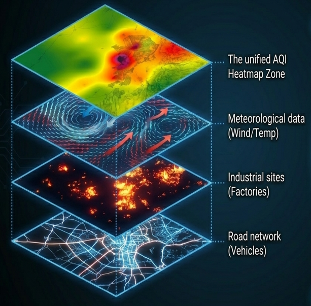
Methodology
The project employs a comprehensive analytical framework based on internationally recognized environmental standards. World Health Organization guidelines are used as reference criteria for evaluating health-related impacts of air pollution, while the United States Environmental Protection Agency Air Quality Index serves as the principal framework for classifying air quality conditions.
Advanced Geographic Information Systems technologies are utilized to analyze and visualize environmental data. Spatial interpolation techniques are applied to estimate air quality conditions in areas where direct measurements are unavailable. This approach allows the generation of continuous air quality surfaces across the entire governorate and facilitates the classification of locations according to health risk categories ranging from Good to Hazardous.
Temporal Analysis
The project recognizes that air quality conditions vary significantly throughout the year. During summer months, regional dust storms and dry climatic conditions contribute to elevated concentrations of particulate matter, particularly PM₁₀. In winter, atmospheric inversion phenomena reduce pollutant dispersion and result in the accumulation of emissions from diesel generators, transportation activities, and industrial operations.
The analysis therefore incorporates seasonal variability to ensure that air quality assessments accurately reflect environmental conditions across different periods of the year.
Project Progress
The project has currently achieved approximately 40 percent completion. Significant progress has been made in securing official environmental data, conducting preliminary analyses, establishing baseline Air Quality Index values, and preparing datasets for advanced spatial modelling.
The project is currently in the AQI calculation phase. The next phase will focus on spatial modeling, validation, and map generation, followed by the development of interactive visualization tools and the preparation of the final report.
Expected Outcomes
The project will produce a comprehensive spatial zoning map of air quality for Sulaimaniyah Governorate, identifying pollution hotspots and areas requiring environmental intervention. The resulting datasets and maps will provide a scientific basis for environmental policy development, urban planning, infrastructure management, and public health protection.
The project will also establish a framework for long-term environmental monitoring and support future initiatives aimed at reducing air pollution and promoting sustainable development throughout the governorate.
Recommendations
Based on preliminary findings, the project recommends expanding the air quality monitoring network throughout the governorate, strengthening environmental regulations governing industrial emissions, enhancing compliance monitoring systems, improving public transportation infrastructure, promoting cleaner technologies, and increasing public awareness regarding the impacts of air pollution on human health.
The generated spatial zoning maps should be integrated into urban planning processes to ensure that residential developments, schools, hospitals, and other sensitive facilities are located away from areas experiencing poor air quality.
Conclusion
The Spatial Zoning of Air Quality Project represents a significant scientific initiative aimed at understanding and managing air pollution in Sulaimaniyah Governorate. Through the integration of environmental monitoring, GIS technologies, spatial modelling techniques, and international standards, the project provides a reliable framework for assessing air quality and identifying pollution hotspots.
The outcomes of this project will contribute to improved environmental governance, enhanced public health protection, informed urban planning, and sustainable development. The resulting air quality zoning maps and recommendations will serve as valuable tools for policymakers, environmental authorities, and local communities in their efforts to create a cleaner and healthier environment for future generations.